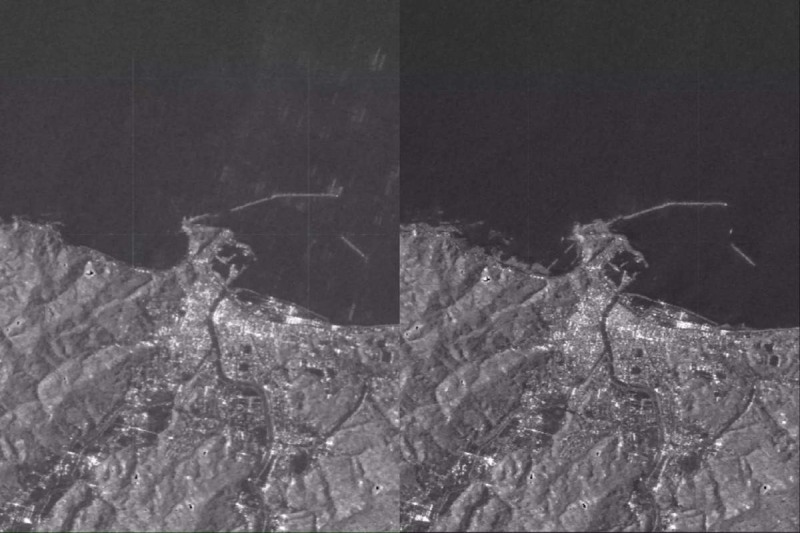
The Noto Peninsula in Japan saw significant alterations to its coastline after a strong earthquake on New Year’s Day, as shown by satellite pictures.
On January 1, at 2:10 a.m. EST (0710 GMT, or 4:10 p.m. local time in Japan), a 7.6-magnitude earthquake rocked Japan, causing authorities to issue evacuation orders for impacted coastal districts that saw considerable elevation. More than two American football fields’ worth of coastline was extended by the strong uplift, according to satellite images taken of the region both before and after the earthquake. This increase in length was as much as 820 feet (250 meters).
Photos of the Noto Peninsula in Japan that were posted on illustrate the parts of the coastline where the seafloor has broken through the ocean to reveal freshly exposed beaches. Once the earthquake and tsunami had passed, the photographs show how the shoreline had changed, with some ports being entirely dry and unusable by boats.
“During a field investigation along the northwest coast of the Noto Peninsula, found evidence at 10 locations, from Kaiso to Akasaki sites, of coseismic coastal uplift related to the Noto Peninsula Earthquake (M7.6),” the University of Tokyo’s Earthquake Research Institute said in a statement on January 4.
“The pattern of estimated coseismic coastal uplift appears to be decreasing southward from Kaiso to Akasaki,” they stated.
The university’s field research uncovered water stains on building walls, indicating that the area around Akasaki port also witnessed tsunamis that reached heights of about 14 feet (4.2 meters).
ALOS-2, an Advanced Land Observing Satellite of the Japan Aerospace Exploration Agency, also recorded the earthquake-induced rise of the coast. According to a statement from the Geospatial Information Authority of Japan, satellite photos compare the coastline from June 2023 to January 2, demonstrating how the shoreline drifted seaward in several regions, including Nafune port, Wajima city, and Minazuki bay.
The statement states that although the satellite photos show notable changes after the Jan. 1 earthquake, examinations along the coast are still ongoing.